The capital of Kermanshah Province, in an altitude of 1, 630 m above sea level, Kermanshah is 525 km to the southwest of Tehran. It can be reached either by air or via Hamadan (190 km), partly on a highway and partly on a first class national asphalt road.
Being a populous city of 631,199 inhabitants, mainly Kurds, Kermanshah stands, like Hamadan, on the great highway that connected Baghdad and the West with Iranian Plateau. The towns situation is highly picturesque, and it is one of the liveliest market centers of the province, where you will meet a large number of Kurds and mountain peasants once famous as warriors. These Kurds still speak their own language among themselves and remain faithful to their testamentary traditions: the men wear large turbans on their heads and black dungarees tight at the waist and at the ankles. The women wear trousers and bright-coloured scarves and sometimes brocade bodices, but they are mostly changing into urban type of dress, particularly in towns.
First built on a site a few km from the present town, it probably dates from the 4th century AD. Its vulnerable position has always rendered it liable to incursions, and it was in turn captured by the Arabs in 649 AD, the Buyids in the 10th century, soon after by the Seljuks, and then sacked by Mongols in the early 13th century. After several centuries of relative peace and prosperity, its strategic position on the road to Baghdad brought trouble in the form of very heavy Iraqi missile and bomb attacks during the Iraqi war against Iran.
Modern Kermanshah is an important agricultural and a burgeoning industrial center. In the surrounding country fruit of many kinds is grown; another local product is sugar-beet. Carpet-weaving and manufacture of givehs (canvas covered shoes like the Spanish alpargata in appearance) have long been carried on in the town. Since the construction of an oil refinery on the banks of Qara Su River in 1935, motor spirit and other petroleum products have been processed there for consumption in northern and north-western Iran.
However, the present Kermanshah does not seem to be of any great interest, especially for a foreign visitor. And although it is not, relatively speaking, an old town, there are some very ancient remains in its neighborhood, which suffice to attract the attention of the interested tourist. It has a beautiful setting, framed by permanently snow-clad mountains. Kermanshah is best avoided in winter, but the climate is very pleasant for most of the rest of the year.
Excursion Around Kermanshah
Buildings and places of interest around Kermanshah are as follows: the Rock Carvings and Inscriptions of Darius I at Bisotun, 32 km east of Kermanshah, in addition to which you will see the relief of a bearded reveler (probably Hercules) with a goblet of wine recently discovered near the main road; the Relief and Inscriptions at Taq-e Bostan; the two Staircases of the Temple of Anahita at Kangavar; the Taq-e Gara (believed to be Sassanian, but the actual date is the subject of much controversy) near the top of the Pay-e Taq pass, approximately 90 km west of the town; the Ruins of Dinavar (dating from the Seleucid era to the late 14th century AD), 45 km east-northeast of the town; the Mound of Kambadene (from Achaemenian to Sassanian times), just to northeast of Kermanshah; and Dokkan-e Davoud (Davids Shop), a Median Tomb of 7th century BC, 3 km from Sar-e Pol-e Zahab, which shows a praying man on a rock piece.
Bisotun:
The Bisotun (or Behistun) mountain stands some 30 km to the northeast of Kermanshah via the main road to Hamadan, which itself follows the ancient caravan route along the bottom of a fine velvety fawn-colored cliff. Long before Achaemenians, even prehistoric man inhabited Bisotun according to Carleton Coon, who found while excavating a cave there in 1949 evidence of a highly developed industry datable to the Middle Paleolithic, indicating that Bisotun was inhabited during the Wurm glaciation.
On the roadside there are Achaemenian inscriptions and relief engraved high up (100 and 40-50 m above the ground) on the Bisotun cliff, which attract the attention of tourists, travelers, and passengers-by. Henry Rawlinson, then subaltern in the British Army, copied the trilingual inscriptions in 1833 and 1834 and eventually began the process of deciphering the Akkadian script which until that time had baffled scholars. Again in 1948 Dr G Cameron of Chicago University could correct some of Rawlinsons errors.
Altogether twelve hundred lines of inscriptions tell the story of the battles Darius had to wage in 521-520 BC against the governors who were trying to dismantle the Empire founded by Cyrus. The decisive battle took place on this site.
A bas-relief portrays the Kings victory; unfortunately the scene showing him with his main enemy at his feet and nine rebel governors enchained, is some 50 m above ground level and is hardly visible without the use of binoculars.
The tablet of Darius I is high up on the side of the cliff over the village of Bisotun which stands to a large pool. Below the tablet is a staircase up to a platform, from which you can see a shallow recess containing an inscription in Greek and a rather worn mid-second century BC sculpture of Hercules (Heracles) on the back of a lion. These sculptures, inscriptions and tablets of considerable dimensions, comprise the figure of Darius I, tall and with attractive features, while Ahura Mazda' symbolic celestial figure can be seen hovering above his head. Darius has stretched his right hand toward this deity and with his left foot he is trampling upon the rebel Gaumata (pretender) lying prostrate at his feet. Two persons are standing behind Darius, while nine governors from different nations are seen before him with their hands tied behind their backs and a cord running around their necks. The name and nationality of each rebel governor have been inscribed as follows:
Atrina (of Susiana)
Nidinter-Bel (of Babylonia)
Faravartish (of Media)
Martiya (of Susiana)
Citrantakhma (House of Sargartiya, in Media)
Vahyazdata (Smerdis in Persis)
Arakha (of Babylonia)
Frada (of Marv)
Skunkha (the Scythian)
The latter figure, wearing a rather tall hat, seems to be later addition. The three languages used in the inscriptions are Babylonian, Elamite, and the Old Persian. The inscriptions are also known as the Longer and the Shorter. The former consists of Ahura Mazdas praise and adoration, the genealogy of Darius, and an account of the events of his reign, his views, beliefs, recommendations, and comments. The Shorter inscription deals with Darius lineage and a number of events taken place during his reign.
These sculptures seem to have been intended to give a true picture of those represented. The Achaemenian sovereign, for instance, wears a garment with folds at the waist. He is 180 cm high.
One of the two prisoners (governors) standing behind the King, bears the royal bow and arrows, while the other is holding the Kings spear. The figure of Ahura Mazda is seen above the heads of the prisoners, with a winged sun-disc (which is the symbol of eternity) encircling him. In the inscriptions, Darius gives the names of his ancestors and says: "Eight of my family were kings before me. I am the ninth. We inherit kingship on both sides."
The Bisotun sculptures (measuring 5.48 by 3.04 m) are of the highest historic importance and have been created in 480 BC, the sixth year of Darius reign. It would take the best part of a Day to explore everything, although most visitors are happy merely to see these famous relieves. Because of the lighting conditions, it is better to visit the site in the early morning and then move on to Taq-e Bostan.
There are plenty of remains at this site. Within easy reach of the cliff there are a Median citadel, the walls of a Parthian settlement, a stone block carved with three Parthian figures, the foundations of a Sassanian bridge, and a grotto with evidence of occupation in Neanderthal times. In Bisotun, there are several places to eat.
Taq-e Bostan:
The bas beliefs at Taq-e Boston (Arch of the Garden), 6 km northeast of Kermanshah, are, with one exception, the only Sassanian rock carvings outside Fars Province; they are also the latest of Sassanian carvings. The Sassanians carved majestic sculptures out of the living rock, mostly in their native province of Fars, designed to exalt their kings and perpetuate their fame. Taq-e Bostan is discovered along the avenue now floodlit: the favourite excursion place of the townspeople. The bas-reliefs decorate two grottoes, large and small, which have been cut out of a rock cliff rising high above a pool of clear water, which recalls the Sassanian site at Darab (Fars Province).
The first one you come to is a majestic bas-relief depicting the investiture of Artaxerxes II, at the same time celebrating a victory over the Romans, by the deity Ahura Mazda to the right and Mithras, holding symbolic sacred bunch of twigs, to the left. The next is a small arched recess carved out of the cliff in the 4th century AD, showing Shapur II and his grandson (later Shapur III), created by the latter as a testament to his own dynastic credentials. The third is a larger grotto, with a lower panel depicting an armored figure holding a lance and seated on a now headless horse, and an upper panel showing a royal investiture. Both are believed to represent Khosrow II, a contemporary of the Prophet Muhammad. The inner walls of this remarkable monument are decorated with relieves of royal hunting scenes, together with a much later addition, a coloured picture of three royal prices added at the time of Fath Ali Shah (Qajar). On the symmetrical facade are two winged angels above some simple floral relieves.
The side-walls have scenes of a royal boar hunt and a royal deer hunt (on the right and on the left, respectively). The hunting party was accompanied by ladies of the court and musicians, all of whom are shown in a style very different from that of the traditional sculpture of the West: this is the art of a jeweler or the miniaturist, the wall being treated as if it were a crown to be covered with precious stones.
Originally decorated in bright colours, the figures are more formal and stylized than those of the Darius relief at Bisotun. The site is fenced off and attended by a curator from the Ministry of Culture and Islamic Guidance. It is open more or less throughout the hours of Daylight, but it is best to come in the mid-afternoon, after visiting the site at Bisotun.
Here, like Bisotun, there are many places to eat: pleasant restaurants with a selection of fried chicken, kebabs and sometimes fish.
Kangavar:
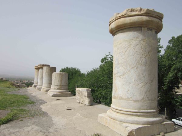
Temple of Anahita: This is one of the architectural monuments of ancient Iran, with its history going back to the Parthian period (200 BC), recently unearthed at Kangavar, 90 km to the east of Kermanshah, and on Hamadan Kermanshah road.
The worship of Anahita goddess of abundance and guardian of water in ancient Iran, and goddess of beauty and fecundity in some other countries was broadly practiced during the Parthian period. However, nothing is said of her existence in numerous Achaemenian inscriptions. The cult of the goddess and the building of temples to her, continued during the Sassanian period. Despite historical references to the temple, its location and architectural decorations by few Muslim and Greek geographers and historians, the greatest bulk of material evidence on the history of the temple and the cult has been gathered as a result of excavations carried out at the temple site on an outcropping rock.
The temple building is a rectangle with its facade to the south. The platform is higher than the ground by several steps, which have completely disappeared. A small mosque has been built to the west, and on the northwest of the temple is a lane along which the best preserved and the most important part of the building is to be seen. This part of the temple is placed on a beautiful foundation of white marble. At this point there are nine white marble columns built into the mud-brick walls of the houses providing a good support for the buildings of the villagers.
Walls, wide steps and marble columns, represent a combination of Irano-Greek architectural styles. Its fortifications have excited archaeologists, although there is no longer that much to see.
Finally, if you like to visit Kermanshah, have a look on our tours and select your favorite itinerary.